Rain to disrupt morning commute in Philadelphia
Meteorologists from the NEXT Weather Team have issued a NEXT Weather Alert, warning of wet roads, reduced visibility, and slower travel times during the early hours. Rainfall totals are expected to range between 0.75 and 1 inch, though some localized areas may receive even more.
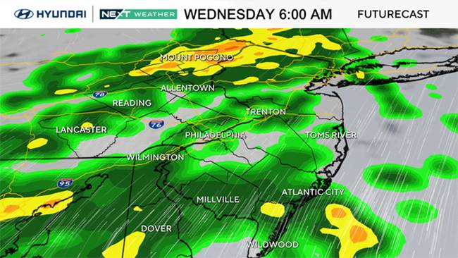
Showers will begin overnight and persist into the early morning, with pockets of heavy downpours possible during rush hour. Fortunately, the rain is expected to taper off around midday, leading to improving conditions as the day progresses. By late morning, clouds will start to break apart, giving way to clearing skies and afternoon sunshine. Despite the brighter outlook, temperatures will dip significantly compared to earlier in the week, making for a cool and crisp autumn day across the region.
Sunshine returns by afternoon, but cooler air settles in
After the morning rainfall moves out, Philadelphia residents can look forward to a noticeable shift in the weather. By around 10 a.m., skies should begin to clear, and by early afternoon, most of the area will enjoy sunshine once again. However, this return of brightness comes with a chill. High temperatures on Wednesday will only reach the upper 60s to near 70 degrees—roughly 10 degrees cooler than recent highs.
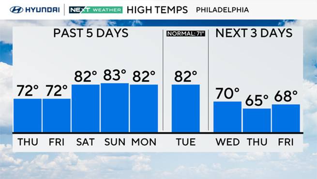
As the sun sets, the cool air will deepen, bringing overnight lows down into the 40s for much of the area. Those heading out Wednesday evening or early Thursday morning will want to grab a jacket. While the sudden temperature change may feel abrupt, it signals a return to typical early October conditions following several mild days.
High pressure brings dry, cool weather through the week
Once Wednesday’s system exits, a strong area of high pressure will move in from the west, ushering in dry and stable conditions for the remainder of the week. Thursday will be sunny but noticeably cooler, with highs only in the low to mid-60s—making it one of the coolest days of the season so far. By Thursday night, temperatures could dip into the low 40s, especially in suburban and rural areas.
Friday will continue the trend of crisp, autumn weather. Sunshine will dominate, and while highs will climb slightly into the upper 60s, overnight lows will remain chilly, with some outlying spots potentially seeing temperatures in the upper 30s. These conditions are ideal for fall activities such as apple picking, pumpkin carving, and enjoying Philadelphia’s fall foliage, which is beginning to show hints of color across the region.
Weekend forecast: clouds increase, rain possible Sunday
The weekend will begin on a mostly dry note, but changes may be on the horizon. Saturday is expected to be mostly cloudy, with highs near 72 degrees—a comfortable and mild day for outdoor plans. However, meteorologists are watching the potential development of a coastal low-pressure system that could form to the south by late Saturday into Sunday.
If the system moves close enough to the Mid-Atlantic coastline, it could bring unsettled weather to the Philadelphia region on Sunday. While there’s still uncertainty surrounding its track and intensity, the possibility of rain showers or periods of steady rain remains on the table. Sunday’s high temperatures are projected around 65 degrees, with overnight lows in the mid-50s.
By Monday, the coastal low could continue to influence the weather pattern, bringing additional clouds or rain depending on its path. Some forecast models suggest the storm may linger offshore before moving away early next week. Tuesday looks more promising, with mixed skies and temperatures rebounding into the low 70s.
Extended outlook and weekly temperature trends
The upcoming week highlights a transition toward more typical autumn weather in Philadelphia. After Wednesday’s rain, the region will enjoy several days of cool, dry air and sunny skies before possibly turning unsettled again over the weekend.
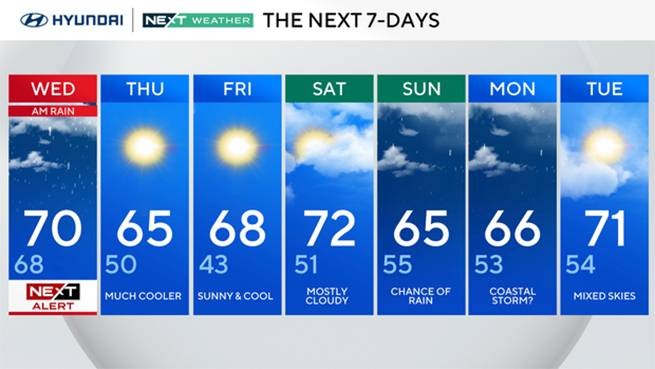
Below is the extended seven-day outlook for the Philadelphia area:
- Wednesday: NEXT Weather Alert for morning rain. High 70, Low 68.
- Thursday: Much cooler and dry. High 65, Low 50.
- Friday: Sunny and cool. High 68, Low 43.
- Saturday: Mostly cloudy. High 72, Low 51.
- Sunday: Chance of rain from coastal system. High 65, Low 55.
- Monday: Possible lingering coastal storm. High 66, Low 53.
- Tuesday: Partly cloudy with mild temperatures. High 71, Low 54.
Overall, this pattern underscores a classic early October setup: alternating between brisk, sunny days and bouts of coastal moisture. Commuters should plan for a wet Wednesday morning, but brighter, calmer days are right behind it.


Yorumlar
Kalan Karakter: